Jess Socrates
Jess Socrates
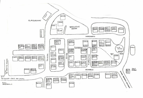
Years before my sister, Mary Ann DeSantis died, she put together a MAP of Area 17 and 14, indicating from her recollection, the families who lived in these homes. I don’t think this map got anywhere except to some of us, her siblings. She might have wanted us to edit/contribute but I never got to doing this. Inspired by the nostalgic comments I have been reading, I searched for this map and scanned this. This is a one-page map on a large piece of paper so I had to arbitrarily divide it into two pages. This first part is mostly Area 17 where we first lived.
For those of you who grew up in Area 17, this is self explanatory. Some additional comments:
At bottom of map is Aunario St. with road to Cruz na Ligas on left and Purok Aguinaldo on right. Names not included by Mary that I remember are Sese and Lorica. Check out vacant lot between Socrates and Santos (mentioned by Joy). Hang out of Area 17 kids. There was big above ground pipe in this area where we would sit or walk on like a balance beam. Lots of ipil ipil trees and a fruit tree name of which I forgot. Anyway, when there were no fruits, my sisters would gather leaves, wrap these in salt and eat them. And there was a canal between our house and this lot. Sometimes we would dam this to gather water for vegetables we planted in this same lot.
Note two playgrounds – on the left by “small” Coop is the NEW playground. My brother Jude’s eye was injured here when the corner of a swing hit him. He still bears the scar! Within the midst of the neighborhood between Sotto and Florentino Streets is the OLD playground. This would occasionally bet overcome by tall talahib grass. Mary’s broken line represents a tall fence that arbitrarily separated Area 14 from Area 14.
The street perpendicular to Tavera is where Jim Campos’ and Leonid Nemenzo’s families lived. The Santos-Cuyugans also lived here but I don’t see this indicated by Mary. Not mentioned by Mary along Tavera St. are the Majuls (Christina) and Daza’s (Sandy and another brother).
The Arcellana’s used to live in Florentino street. I forgot that the Lagmay’s (you are right Bubu, they were the “Yabu” family) used to live in Area 17 before they moved to Area 14.
The Hidalgo home on the right most must have originally been a storage facility (roof shaped like UP gym or UP theater roof i.e. semi-circular)
Check out the “club house”
Maramag St. parallel to Aunario is where we moved to, close to Executive House. Seems like I was wrong in saying that the Nemenzo’s were next to us. Refer to second Map. The Madrid’s (Daphne and cousin Betsy, my UP Elem and High batchmates) used to live here as well. One of the homes on this street was occupied by the Panlasigui's (Didi was also my UP Elem/ High classmate).
Give me time to work on the second part (mostly Area 14). If you want a higher resolution map, I can email to you personally. Send me an email at: [email protected]
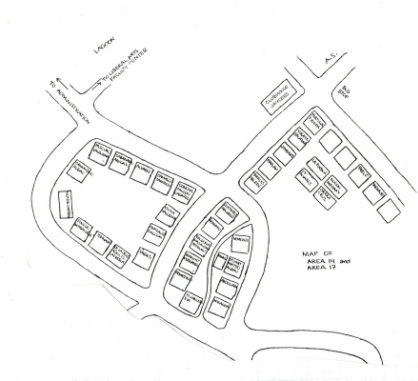
Mary Ann Socrates DeSantis' first map of Area 14 and 17

Batang UP Campus 60-70-80's by Candy Lagmay Bandong is licensed under a Creative Commons Attribution-NonCommercial-NoDerivs 3.0 Unported License.
